1/1
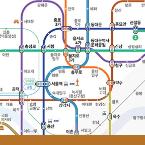
Subway Map for the Color Blind
Subway Map for the Color Blind is designed for the three percent of the population that is color blind and has difficulty identifying information visually. Original straight lines are redesigned into curves to show direction; routes are outlined to reduce confusion; and transfer stations are labeled with numbers for faster and easier recognition. Local characteristics are added with symbols, and the routes are drawn to represent the actual route as much as possible. The new map results in 50 percent faster transition upon arriving at an unfamiliar station for the colorblind; and by 20 percent for those who have regular vision.
发布于2020-02-14
设计师
HyoJung Kim, HyunSoo Kim, Rae Na, Geon Yang and HeeJeong Son of NAVER
设计奖项
美国IDEA工业设计奖
Bronze/铜奖
2016 年
颜色

